

Walking the ‘Ethels’
What started out as a ‘little idea’ from an app-developing friend of the charity, has taken off with quite a large following ….. there are now over 30,000 downloads of the app
We’re very grateful to Doug for writing the app and to all of the media outlets that have covered it. For those of you that do not have a smartphone, Doug has written a page for wikipedia listing the ‘Ethels’.
Please note the following important points –
The decision on which points to include on the list was made by the app developer not the charity.
Some of the ‘Ethels’ are NOT on Open Access Land. The homepage of the app, and the pages for each hill contain important access information – please read them.
Please direct any issues with the app to the developer.
We have deliberately not stated any particular route up or down any of the hills – please choose your own and please keep to Public Rights of Way (PRoW) – there is a guide from Ordnance Survey to the different types of PRoW HERE
We would strongly recommend that you know how to use a map and compass – and we ask that you follow the Countryside Code
For those of you with energy left in your legs … we have revised the guidebook to our very own Peak District Boundary Walk which is a 200 mile walk in stages around the National Park.
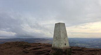
The picture is of the trig point on White Path Moss (on Stanage)