

Sheffield Green Belt Land Set for Release Amid Housing and Employment Expansion Plans
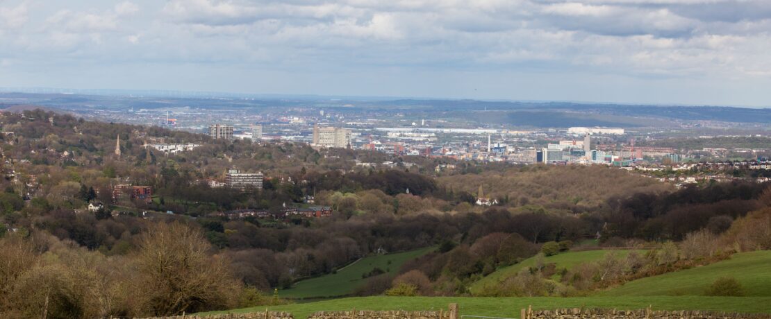
Sheffield is on the verge of a significant shift in its proposed local development plan as the city council conclude that there are exceptional circumstances to justify the release of greenfield land from the Green Belt for housing and employment sites.
Sheffield City Council is looking into whether areas of Green Belt land could be used for housing, given the high demand for homes and limited land supply. Since national planning rules (National Planning Policy Framework (NPPF)) only allow Green Belt land to be released in “exceptional circumstances” they are carefully assessing the impact of doing so. Alongside this, they are reviewing the location of employment developments outside Sheffield’s urban area to further support the city’s economic growth.
Councillors will discuss the release of Green Belt land at an upcoming Strategy and Resources Policy Committee meeting in public on Wednesday 30th April 2025 at the Town Hall.
Findings indicate that some of the proposed development sites score weakly or modestly against the key purposes of Green Belt designation. As a result, the Inspectors along with the Council believe that selected greenfield Green Belt sites could be justified for release, ensuring a balance between meeting development needs and maintaining the integrity of Sheffield’s Green Belt. However, some higher scoring sites are also earmarked for development as these are thought to be needed to meet housing and employment needs.
The Council will be urged to accept that the conditions for exceptional circumstances are met and should therefore proceed with allocating some Green Belt land for housing and employment. If adopted, this move would mark a pivotal moment in Sheffield’s urban development, raising discussions on sustainability, infrastructure, and community impact.
Proposed Additional Site Allocations
A list of new proposed site allocations for housing that would provide the amount of land required to enable the Sheffield Plan to be found sound by Government Inspectors, will be recommended for public consultation in May.
The proposed sites have been published in a new report which identifies proposed green belt sites in Sheffield’s north west, north east, east, south east, south, south west, Stocksbridge, Deepcar, Chapeltown and High Green.
You can also use the Google Map below and click on the purple and black markers to learn more about the proposed developments on Green Belt land.
Housing sites (<1,000 homes) in the Green Belt are now being considered after an updated assessment: during the Local Plan Examination, the Inspectors asked the Council to expand the scope of the original integrated impact assessment (IIA) to include housing site options (<1,000 homes) in the Green Belt, on the grounds that this is a reasonable alternative strategy option and should therefore be subject to appraisal (the original IIA only considered strategic Green Belt releases of over 1,000 homes). The IIA has been updated to reflect the Inspectors’ request.
The 14 proposed sites could provide nearly 4,000 new homes and over 67 hectares of employment land; the sites provide an estimated capacity for 3,948 dwellings and 67.35 ha of employment land.
Most new sites would be in the North and Southeast of Sheffield; 69.78% of the proposed housing sites are in the north and southeast of the city, with the largest proposed site at Handsworth Hall Farm for 870 homes.
Eight of these sites would be classified as ‘strategic’ under the Sheffield Plan; which means they have capacity for over 200 new homes or are over 4 hectares.
New planning applications for the sites would have to follow similar requirements to the NPPF ‘Golden Rules’; planning applications on any site allocations that were formerly Green Belt land would be subject to Local Plan policy which is similar to the ‘Golden Rules’ which were introduced by the new NPPF. These ‘Golden Rules’ have introduced specific enhanced requirements in relation to the provision of affordable housing, infrastructure and open space.
Green Belt land used for housing must deliver more affordable homes than non-Green Belt areas: The draft Sheffield Plan policy proposes setting a 30% requirement in the southwest, south and northwest of the city and a 10% requirement in all other areas. However, under the NPPF, on former Green Belt land the requirement would be for at least 50% of the housing to be affordable, unless this would make the development of these site unviable.
Some boundary adjustments would be made to ensure a logical and defensible Green Belt; The allocation of some of the sites would necessitate further alterations to the Green Belt boundary in order to create a logical and defensible Green Belt boundary.
Overall, 3.6% of Sheffield’s Green Belt would be removed; The current total area of the Sheffield Green Belt is 9,061 hectares. The amendments to the boundary proposed in this report would result in 327.45 hectares being removed from the Green Belt.
Measures to manage increased recreational pressure on the National Park are in discussion; recreational pressure within the National Park is expected to increase, so a range of mitigation measures have been discussed with the National Park Authority with a view to working jointly with other stakeholders on a mitigation strategy.
Public rights of way on former Green Belt land would be preserved, ensuring continued access; Where public rights of way currently exist on land to be removed from the Green Belt for development, conditions on development will ensure that these are maintained and that access into the wider Green Belt remains.
What’s next?
The coming weeks and months will be crucial as discussions unfold on how best to move forward with Sheffield’s evolving landscape, with a full council meeting taking place on 14th May 2025.
The most recent Local Development Scheme (LDS) for the Sheffield Plan (March 2025) sets out the timetable and process for producing the Plan and shows it being adopted by July 2026. The next steps are:
- Consultation – representations on the proposed additional site allocations and submission document updates – late-May – mid-July 2025
- Continuation of public examination – stage 3 and 4 hearings – September/October 2025
- Inspectors Preliminary Report including recommended Main Modifications – November 2025
- Consultation on Main Modifications – February – March 2026
- Inspector’s final report – June 2026
- Adoption – July 2026
Understandably, we are expecting public reactions to be mixed. As advocates for the countryside, we remain committed to carefully assessing the impact of Green Belt land loss on a case-by-case basis, weighing it against the potential benefits for achieving a more sustainable City by meeting housing, employment, health wellbeing and nature recovery needs.
Thanks to the generous support of our donors, we can continue our mission to foster a thriving countryside that serves communities, people, and the planet.